Have you ever looked at a California real estate parcel and wondered why you can build a massive duplex on one lot, but on the exact same sized lot next door, you aren’t even allowed to add a second story? The answer lies hidden inside California zoning maps. For real estate investors, developers, or anyone looking into California property records, understanding how local planning departments regulate land use is the difference between a highly profitable investment and an expensive legal nightmare. Every city and county across the Golden State uses its own local municipal codes to control development. This comprehensive guide will break down how to read a California zoning map, decode the most common zoning designations, and find the exact land use rules for any parcel.
What is a California Zoning Map?
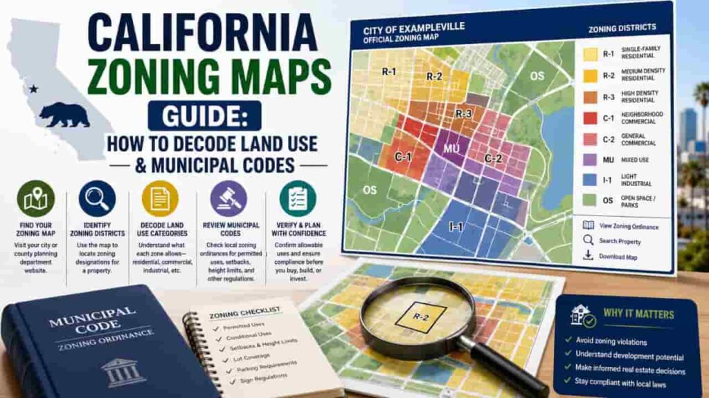
A zoning map is an official visual document mapped out by a local planning department (such as the Los Angeles Department of City Planning or San Francisco Planning). It divides a city or county into distinct geographic sectors called land use zones.
Standard Planning Codes (Statewide) ──> Local Municipal Codes (City/County) ──> Specific Parcel Restrictions
While the State of California sets general frameworks (like the Planning and Zoning Law under Government Code Section 65800), the actual power to enforce these rules belongs to local municipalities. Each city or county designs its own master plan, known as a General Plan, and uses zoning maps to bring that plan to life legally.
The Connection Between the General Plan and Zoning
Many beginners confuse a General Plan map with a Zoning Map. Here is how they actually connect.
- The General Plan
A long term, high level vision for the next 15 to 20 years. It outlines broad categories like “Residential” or “Commercial.” - The Zoning Map
The active, legal tool that enforces the General Plan. It provides microscopic details for every parcel, including exact setback requirements, maximum height limits, and lot coverage percentages.
Decoding California Zoning Designations, R1, C1, and M1
When you open a local GIS mapping tool or look at a city zoning map, you will see a colorful grid marked with alphanumeric codes. While California doesn’t have a single, statewide mandatory coding system, most local planning departments base their ordinances on traditional, industry standard planning codes.
The table below breaks down the primary zoning designations used across California municipalities.
| Zone Type | Common Code Prefixes | Allowed Land Uses & Examples |
| Residential | R1, R2, R3, RE, RM | Single family homes, duplexes, multi family apartment complexes, and accessory dwelling units (ADUs). |
| Commercial | C1, C2, CC, CR | Retail stores, professional office buildings, restaurants, medical clinics, and shopping centers. |
| Industrial | M1, M2, MR, MR1 | Manufacturing plants, warehouses, auto repair shops, distribution centers, and storage facilities. |
| Agricultural & Open Space | A1, AG, OS, O | Farming, livestock, public parks, environmental conservation zones, and protected state lands. |
Understanding the Numbers in the Codes
The numbers attached to the letters usually signal the intensity of the land use.
- R1 (Single Family Residential)
Typically allows only one primary housing unit per lot. - R3 (Multiple Family Residential)
Allows higher density, meaning you can build apartments, condominiums, or multi unit townhomes depending on the total square footage of the lot.
The 3 Pillars of Development, Setbacks, FAR and Height Limits
Finding the letter code on a zoning map is only half the battle. To truly understand what can be built on a piece of California land, you have to dig into the text of the local municipal codes. Local planning departments use three specific metrics to control the physical shape of a building.
1. Setback Requirements
A setback is the minimum legal distance a building must be placed from property lines, streets, or other structures.
- Front Setback. Keeps buildings from encroaching on city sidewalks or streets.
- Side Setbacks. Ensures there is space between neighboring properties for fire safety and privacy.
- Rear Setback. Usually creates yard space or allows utility access at the back of the property.
2. Floor Area Ratio (FAR)
Floor Area Ratio is a metric that limits the total usable floor space of a building relative to the size of the plot of land it sits on. It is calculated with a straightforward formula.
FAR = Total Gross Floor Area of the Building \ Total Area of the Lot Parcel
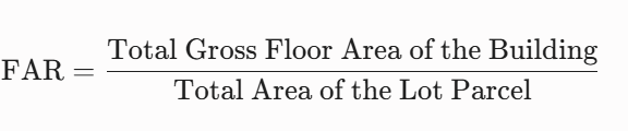
For example, if you own a 10,000 square foot lot and the local municipal code specifies a maximum FAR of 0.5, your total building layout cannot exceed 5,000 square feet of floor space. This could be a single story building covering 5,000 square feet, or a two story building covering 2,500 square feet per floor.
3. Height Restrictions and Lot Coverage
Even if your FAR allows for a larger building, local codes usually impose strict maximum height limits (often measured in both feet and total stories) to preserve neighborhood character and sunlight access. Lot coverage limits also prevent a building from completely paving over a lot, ensuring enough unpaved ground remains to handle rainwater drainage.
Step by Step Guide, How to Find the Zoning Rules for Any California Property
If you are researching a specific property for development, resale, or investment value, you can find the authentic zoning rules by following this step by step process.
1-Prerequisite. Locate the Property APN
Find the Assessor’s Parcel Number (APN) or the exact street address. The APN can be found on the latest property tax bill or via county property records.
2-Online Search. Access the Local Planning GIS Map
Go to the official website of the city where the property is located (or county website if it is in an unincorporated area). Look for their “Interactive Zoning Map” or “GIS Mapping Portal.”
3-Map Analysis. Identify the Exact Zone Code
Type the address or APN into the interactive map. Note the exact alphanumeric code assigned to the parcel (e.g., “LA R3” or “C 2”).
4-Code Verification. Cross Reference the Municipal Code
Open the local municipal code database (frequently hosted on platforms like Municode or American Legal Publishing). Look up the specific section dedicated to that zoning code to read the allowed uses, setbacks, and development rules.
Critical California Overlay Zones & State Level Exceptions
While local municipal codes form the foundation of zoning, California features several unique state laws and overlay zones that can completely alter local restrictions.
The Coastal Zone Overlay
If a property sits anywhere near the Pacific Ocean, it likely falls within the jurisdiction of the California Coastal Commission. The Coastal Zone overlay adds strict environmental reviews, view protection laws, and rigorous permitting processes that override standard city permissions.
Senate Bill 9 (SB 9) and ADU Laws
In recent years, the State of California has passed aggressive housing legislation designed to tackle the housing shortage. These state level laws frequently bypass strict local R1 single family zoning rules.
- Accessory Dwelling Units (ADUs)
California law allows homeowners to add detached or attached ADUs (often called granny flats) on residential lots, regardless of local density limits. - Senate Bill 9 (SB 9)
Allows property owners in urbanized single family residential zones to split a single lot into two separate parcels, or build up to two primary residential units on a single lot, effectively opening up R1 zones for multi unit development.
Before finalizing any real estate transaction or development budget, always schedule a pre application consultation with the local city or county planning department staff. They can verify if any hidden overlays, historic preservation zones, or new state housing laws apply directly to your specific parcel.
Key Takeaways
The California zoning maps and decoding municipal codes like R1, C1, or M1 is the foundation of smart real estate development. While local planning departments dictate strict setback requirements and land use zones, shifting statewide housing laws like SB 9 and ADU mandates continue to create massive density opportunities across the Golden State. To avoid costly compliance issues, always verify your parcel’s exact zoning designations through official county GIS portals and consult local building officials before breaking ground.
FAQs
How do I find the zoning map for my property in California?
Visit your local city or county planning department website and look for their interactive GIS mapping portal. Enter your address or Assessor’s Parcel Number (APN) to view local zoning designations.
What does R1 zoning mean in California?
R1 stands for Single Family Residential. It restricts land use zones primarily to one standalone home per lot, though recent state laws now allow for Accessory Dwelling Units (ADUs).
Can I build a duplex on an R1 lot in California?
Yes. Under Senate Bill 9 (SB 9), many urbanized R1 single family parcels across California can legally be split or developed with up to two primary residential units.
What is the difference between C1 and M1 zoning codes?
C1 denotes Commercial zones used for retail, offices, and restaurants. M1 signifies Light Industrial zones, which allow for manufacturing, warehouses, distribution centers, and auto repair shops.
How do setback requirements affect my building size?
Setbacks define the mandatory legal distance a structure must keep from property lines. They directly limit the buildable footprint, reducing the total available area for development.
Where can I read the official text for a city’s municipal codes?
Most California cities publish their complete municipal codes online via public legal databases like Municode, American Legal Publishing, or directly on the city clerk’s portal.
What happens if my project violates local floor area ratio (FAR)?
Your building permit application will be denied by the local planning department unless you apply for and receive a formal zoning variance or conditional use permit.
Does the California Coastal Commission affect local zoning maps?
Yes. Properties within the designated Coastal Zone overlay must comply with strict environmental and view protection rules, which completely override standard city municipal codes.
What is a zoning variance in California real estate?
A variance is a special administrative exception granted by a local planning board allowing a property owner to bypass specific physical zoning rules like height limits or setbacks.
How often do California cities change their zoning maps?
Zoning maps change incrementally through amendments, but major overhauls occur when a city updates its comprehensive General Plan, which typically happens every 15 to 20 years.