A gorgeous home tucked into the foothills of Northern California, surrounded by towering pine trees, or a pristine hillside lot in Southern California with panoramic mountain views. The price perfectly aligns with your target budget, the neighborhood is quiet, and the local schools are excellent. However, right before you close escrow, you receive an astronomical quote for property insurance or worse, a string of immediate policy denials from traditional insurance providers. You suddenly find out that your future home is located inside a state designated, high risk climate danger zone. In the Golden State, tracking environmental risks is no longer just a minor footnote on a real estate checklist; it is a critical piece of property due diligence that can save you from a massive financial mistake. As atmospheric shifts fuel intense dry spells and seasonal winds, running a California wildfire zone map property lookup before buying real estate is absolutely essential. This comprehensive guide will teach you how to use official CAL FIRE maps, decode complex risk classifications, and understand the massive impact these zones have on home insurance CA rates and local building laws.
What is a Fire Hazard Severity Zone (FHSZ)?
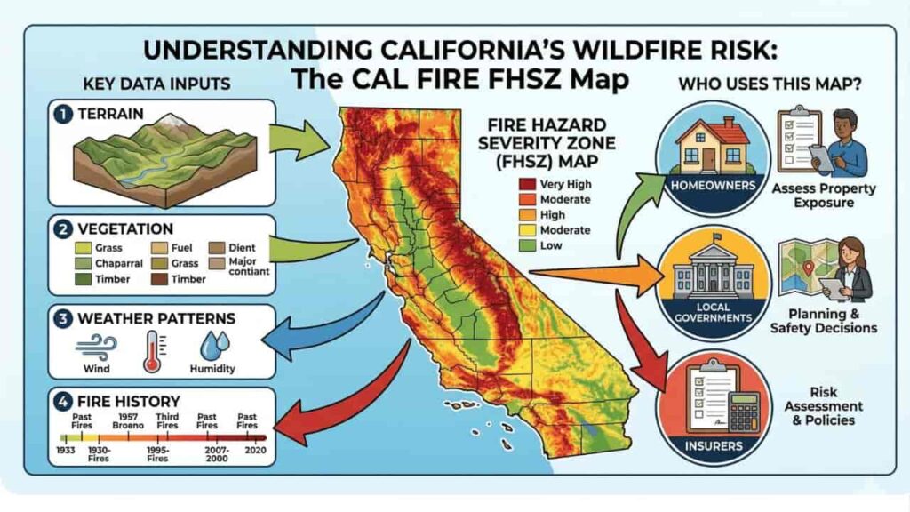
A Fire Hazard Severity Zone (FHSZ) is a formal geographic area mapped out by the California Department of Forestry and Fire Protection (CAL FIRE). These zones evaluate the long term likelihood and intensity of a wildfire damaging a specific area over a 30 to 50 year window
[Topography & Fuel Density] ──> CAL FIRE Science Models ──> FHSZ Map Designation ──> Insurance & Building Mandates
Rather than looking at a single fire season, CAL FIRE scientists use advanced computer models to evaluate multi decade physical hazards. These models calculate risk based on regional vegetation (fuel loads), typical wind patterns, hillside slopes, and how easily embers can fly into an area and spark secondary fires.
Decoding CAL FIRE Severity Tiers & the WUI
When you review a property on a state fire map, your parcel will fall into one of three official severity tiers. Additionally, the map will indicate if your property sits within a specific urban risk interface.
The Three Official FHSZ Tiers
- Moderate FHSZ
Typically features lower fuel densities and flatter land layouts, resulting in lower history of rapid wildfire spread. - High FHSZ
Found in areas with denser brush, rolling hills, and weather patterns that make them highly prone to seasonal fire containment challenges. - Very High FHSZ
The most restrictive tier. These areas feature heavy fuel loads, steep mountain topography, and a severe vulnerability to extreme fire behavior.
Understanding the Wildland Urban Interface (WUI)
A massive portion of California’s real estate development sits within the wildland urban interface (WUI). The WUI (pronounced WOO ee) is the zone where residential neighborhoods meet unoccupied, fire prone wildlands. If your property lookup falls within a designated WUI zone, your home faces distinct state regulations regardless of its base municipal zoning.
The table below outlines how these official CAL FIRE map layers impact building codes and real estate rules.
| Map Overlay Designation | Regulatory Authority | Building Code & Disclosure Mandates |
| Very High FHSZ | State Responsibility Area (SRA) or Local (LRA) | Strict Chapter 7A fire resistant materials required; mandatory natural hazard disclosure (NHD) at resale. |
| High / Moderate FHSZ | State Responsibility Area (SRA) | Standard defensible space inspections apply; wildfire disclosure forms required for property transactions. |
| WUI Overlay Zone | Mixed Local & State Jurisdictions | Mandatory flying ember protection vents required; strict local brush clearance rules enforced. |
The Insurance Crisis, How Fire Maps Control Policy Rates
The primary reason real estate investors and homebuyers look up a California wildfire zone map property registry is to evaluate their future home insurance CA options. Over the past several years, high risk fire designations have fundamentally changed the state’s property insurance market.
Admitted Carrier Withdrawals
Traditional, mainstream insurance companies (known as admitted carriers) use CAL FIRE maps alongside private data tools to manage their financial risk. If a property falls within a High or Very High FHSZ, many traditional insurers will decline to write a new policy or choose not to renew existing coverage.
The California FAIR Plan
If you buy a home inside a severe fire zone and cannot find coverage from a standard insurance company, your fallback option is the California FAIR Plan. The FAIR Plan is a state mandated, high risk insurance pool funded by all insurance providers operating in California. While the FAIR Plan guarantees access to a basic fire policy, it operates as a policy of last resort. It carries significantly higher annual premiums than traditional policies and requires you to purchase a separate “Difference in Conditions” (DIC) policy to cover standard items like theft, water damage, and personal liability.
Step by Step Guide, How to Check a Property’s Wildfire Risk Rating
Before removing your contingencies on a California real estate contract or investing in land development, use this step by step workflow to audit your property’s official fire classification.
Step 1. Locate Your Assessor’s Parcel Number (APN)
Find your unique APN on your property tax bill or search the street address on your local county assessor’s web lookup utility.
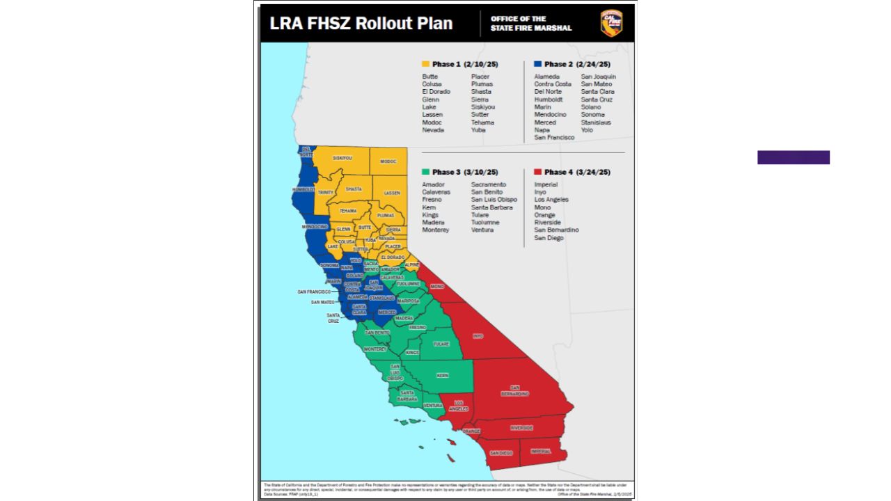
Step 2. Launch the Official CAL FIRE FHSZ Viewer
Go to the official CAL FIRE website and open their interactive Fire Hazard Severity Zone Viewer tool. Avoid third party real estate blogs, as state fire maps undergo periodic updates by the Board of Forestry and Fire Protection.
Step 3.Input the Address and Identify Your Jurisdiction Zone
Type your address or APN into the search input. Note whether your property sits within a State Responsibility Area (SRA) where CAL FIRE provides primary emergency services or a Local Responsibility Area (LRA) managed by a city fire department.
Step 4. Verify the Exact Hazard Severity Rating
Look at the color coded layer covering your parcel. Determine if the ground is mapped as Moderate, High, or Very High. If the map displays a crimson red shade, your lot sits inside a Very High FHSZ.
Step 5. Request an Insurance Quote and Defensible Space Audit
Send your map details to an insurance broker to check your eligibility for coverage. If buying an existing home in an SRA, request a formal CAL FIRE Defensible Space Inspection (Assembly Bill 38 compliance) to ensure the seller clears any active brush violations before closing.
Mandatory Hazard Mitigation, Defensible Space and Hardening
Owning a property in a high risk zone means you must comply with strict state laws designed for hazard mitigation. California enforces two main fire safety frameworks to protect homes from wildfire damage.
1. Defensible Space Mandates (Public Resources Code 4291)
California law requires homeowners in mountainous or high risk areas to maintain 100 feet of defensible space around all occupied structures. This space is split into distinct safety zones.
- Zone 0 (The Ember Resistant Zone)
The first 5 feet extending outward from the home. This area must be completely clear of combustible materials, wood bark mulch, dead leaves, and overhanging tree limbs. - Zone 1 (The Lean, Clean, and Green Zone)
From 5 feet to 30 feet from the structure. All dead plants must be removed, and tree canopies must be trimmed to maintain a 10 foot separation between trees. - Zone 2 (The Reduced Fuel Zone)
From 30 feet to 100 feet from the structure. Horizontal and vertical spacing between native bushes and trees must be maintained to keep fire from climbing into the tree canopy.
2. Home Hardening Standards (Chapter 7A)
If you plan to build a new property or expand an existing footprint inside a high risk zone, your construction plans must comply with California Building Code Chapter 7A. These rules require building with fire resistant materials, including multi pane tempered glass windows, ignition resistant ignition resistant stucco or fiber cement siding, fire proof synthetic decking, and specialized attic vents designed to block flying embers from entering your home.
Key Takeaway
Checking a California wildfire zone map property registry is a foundational step for protecting your family and your financial investments. High risk fire zone designations dictate your construction costs, shape your long term property disclosures, and heavily impact your monthly home insurance CA premiums. By using official CAL FIRE mapping utilities early, maintaining proper defensible space zones, and accounting for home hardening standards, you can build a resilient property that is fully prepared for California’s seasonal climate challenges.
FAQs
Where can I officially check if a property is in a high risk fire zone?
You can search your address or parcel number on the official interactive Fire Hazard Severity Zone (FHSZ) map viewer hosted on the CAL FIRE website.
What is the California FAIR Plan?
The FAIR Plan is a state mandated property insurance program of last resort that provides basic fire coverage to homeowners who have been denied traditional insurance policies.
Does a “Very High” fire zone map code block me from building?
No. It does not stop you from building, but it forces your project to comply with strict Chapter 7A home hardening building codes and materials.
What is the Wildland Urban Interface (WUI) zone?
The WUI is the geographic area where residential housing developments meet undeveloped, fire prone wildlands, creating distinct structural fire risks.
How far out must I clear brush around my California home?
Under Public Resources Code 4291, you must maintain 100 feet of clean defensible space around all primary structures on your land.
What is an Assembly Bill 38 (AB 38) fire disclosure?
AB 38 requires sellers of properties inside high risk zones to provide buyers with official proof that the lot passed a recent defensible space inspection.
What is the difference between an SRA and an LRA map layer?
An SRA (State Responsibility Area) means CAL FIRE handles wildfire protection, while an LRA (Local Responsibility Area) means city or county emergency crews handle protection.
Can a traditional insurance company cancel my policy due to a new fire map?
Yes. Insurance companies routinely review updated state fire maps to adjust their risks, which can result in policy non renewals for high risk properties.
What are attic ember resistant vents?
These are specialized construction vents built with fine wire mesh designed to block flying embers from entering your attic and starting a fire inside the roof.
How often does CAL FIRE update its fire hazard severity maps?
CAL FIRE overhauls its statewide maps every 10 to 15 years, using updated vegetation data, historical wind tracking, and modern climate modeling.