Owning a piece of prime real estate along California’s iconic 1,100 mile coastline whether a beachside cottage in Malibu, a cliffside lot in Big Sur, or a commercial storefront in San Diego is a major investment milestone. However, if you plan to build, remodel, or develop any structure near the Pacific Ocean, standard city and county ordinances are not the final word. Your property answers to a much higher regulatory authority. The California Coastal Commission. Many buyers make the critical mistake of assuming that a standard local building permit is all they need to break ground on a coastal lot. They quickly find out that their project falls inside a highly protected, state governed boundary line. Strikingly strict environmental protection laws can instantly freeze construction if proper state clearances are ignored. Before purchasing or developing any shoreline property, checking an official California coastal zone map is your most important step. This comprehensive guide will show you how to use public coastal mapping systems, decode jurisdictional lines, and secure the necessary approvals to protect your investment.
What is the California Coastal Zone Boundary?
The California Coastal Commission was established by voters in 1972 and made permanent by the landmark California Coastal Act of 1976. The Commission is an independent state agency tasked with protecting public beach access, preserving marine habitats, and managing the structural balance of shoreline developments.
[1976 California Coastal Act] ──> State Coastal Commission ──> Public Boundary Maps ──> Local CDP Oversight
The Commission’s legal authority is tied to a specific boundary line known as the California Coastal Zone. This is not a uniform line; its width varies depending on local geography.
- Urban Shorelines
In crowded city centers, the zone may extend only a few hundred yards inland from the mean high tide line. - Rural and Coastal Landforms
In undeveloped, ecologically sensitive rural areas, the boundary can stretch as far as 5 miles inland to protect critical watersheds and coastal ridgelines.
Local Coastal Programs (LCPs) vs. Direct State Control
To manage this massive jurisdiction smoothly, the Coastal Act requires local cities and counties along the coast to draft a Local Coastal Program (LCP). The LCP acts as an amendment to the city’s standard zoning plan, tailoring it to match state conservation goals.
The table below outlines how jurisdictional authority shifts depending on the exact location of your property boundary map.
| Project Location | Primary Permit Authority | Appeal and Review Framework |
| Tidelands & Public Trust Lands (Beaches, wetlands, submerged lots) | California Coastal Commission | Direct state jurisdiction; no local authority overrides are allowed. |
| Inland Coastal Zone (Lots with a certified local LCP) | Local City or County Planning Board | Permits are issued locally but can be formally appealed to the State Commission. |
| Inland Coastal Zone (Areas without a certified LCP) | California Coastal Commission | The state retains full, direct control over all development reviews. |
The Regulatory Gatekeeper, The Coastal Development Permit (CDP)
If your California coastal zone map search confirms that your property sits inside the boundary line, you cannot build or make major property changes by right. You must secure a specialized Coastal Development Permit (CDP) before your local building department can issue any standard construction permits.
What Counts as “Development”?
Under the Coastal Act, the word “development” covers far more than just constructing a brand new house. A CDP is required for.
- Building new residential structures, guest houses, or retail spaces.
- Making major additions or structural remodels to an existing home.
- Changing land density through lot splits or subdivisions.
- Clearing native vegetation, grading soil, or changing public access routes to the shoreline.
Investor Note. Do not assume a minor project is automatically exempt. Even building a simple retaining wall, clearing brush for fire safety, or installing a new perimeter fence on a beach property zoning lot can require a formal CDP review if the site is near a public bluff or sensitive habitat.
Step by Step Guide, How to Run a California Coastal Zone Map Lookup
Before closing on a beach area property or finalizing architectural layouts, follow this professional step by step process to verify your project’s legal jurisdiction.
Step 1. Find Your Property’s Assessor’s Parcel Number (APN)
Locate your unique APN on a recent county tax statement or look it up by address using your local county assessor’s online database.
Step 2 Launch the Official Coastal Commission Mapping Tool
Go to the official California Coastal Commission website and open their digital Coastal Zone Boundary Web Map. Avoid third party real estate mapping tools, as they may lack recent jurisdictional adjustments.
Step 3. Input Search Parameters and Locate the Line
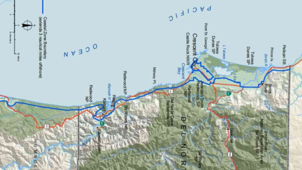
Enter your address or APN into the interactive lookup utility. The digital map will show a distinct, colored line marking the official boundary of the state’s coastal zone.
Step 4. Determine Appeals Jurisdiction Overlays
Look closely to see if your lot falls within the “Appeals Jurisdiction” layer. If your lot is within this zone (typically within 100 feet of a wetland, stream, or coastal bluff), any permit approved by your local city hall can be challenged and overturned by the state commission.
Step 5. Consult with Local and State District Planners
Take your map printouts and preliminary architectural concepts to your local city planning counter and the nearest Coastal Commission district office (such as the Central Coast, South Coast, or North Coast branch) to verify your target application timeline.
Key Takeaways
Running a California coastal zone map lookup is an absolute requirement for successful real estate due diligence along the Pacific shoreline. A property’s proximity to the coast dictates its building limitations, shapes its environmental reviews, and determines whether you must go through the complex Coastal Development Permit (CDP) process. By using official state mapping tools early, verifying local LCP guidelines, and identifying appeal overlays, you can safely manage your development projects and ensure your beachside investments remain fully protected.
FAQs
How can I verify if my plot sits inside the California Coastal Zone?
You can search your specific address or APN directly on the official interactive Coastal Zone Boundary Web Map hosted on the California Coastal Commission website.
What is a Coastal Development Permit (CDP)?
A CDP is a mandatory land use permit required for any building, remodeling, or land modifications inside the state designated coastal zone boundary.
Can a local city approve a beach project without the Coastal Commission?
Only if the city has a state certified Local Coastal Program (LCP). However, if the project sits on public tidelands or inside an appeal zone, the state commission can still review and override the approval.
What is a Local Coastal Program (LCP)?
An LCP is a local planning framework that adapts a city or county’s standard zoning codes to align with the environmental and conservation mandates of the California Coastal Act of 1976.
Does remodeling an existing beach house require a CDP?
Yes. While minor interior repairs may be exempt, major structural expansions, floor plan alterations, or projects on coastal bluffs almost always require a CDP.
What does “Appeals Jurisdiction” mean on a coastal map?
It identifies a high risk regulatory strip where a local city permit can be formally appealed by community members or coastal commissioners and re evaluated at a state hearing.
How far inland does the California Coastal Zone map boundary reach?
The boundary ranges from a few hundred yards in dense urban areas up to 5 miles inland in rural, ecologically sensitive coastal spaces.
Can I block public access to the beach if I own a waterfront lot?
No. The California Coastal Act strictly protects public access to the shoreline, meaning private gates or fences cannot block legally recorded public beach paths.
How long does it take to secure a Coastal Development Permit?
A straightforward local CDP can take 3 to 6 months to process, while complex projects requiring direct state commission review can take a year or longer.
What is an ESHA overlay on a coastal property map?
ESHA stands for Environmentally Sensitive Habitat Area. If your property map shows an ESHA overlay, development is heavily restricted to protect rare plant or animal species.