Imagine buying your dream property in California, drawing up plans for a pristine backyard swimming pool or a detached guest house, and hiring a contractor to break ground only to receive a sudden cease and desist order from a local utility company. You discover that a massive, invisible underground water main cuts directly through your yard, and building anything permanent over it is strictly illegal. This nightmare scenario happens to unsuspecting buyers across the Golden State every year because they fail to check for hidden land restrictions beforehand. An easement grants a specific third party like a neighbor, a city worker, or a utility provider the legal right to use a portion of your land for a designated purpose. Finding these boundaries on an official property boundary map is a critical part of real estate due diligence. This expert guide will teach you exactly how to find property easements in California, interpret map symbols, and review public records to protect your property rights.
What is a Property Easement in California?
Under California Civil Code Section 801, an easement is a nonpossessory interest in another party’s land. It does not mean someone else owns your land; rather, it means you cannot block them from accessing their legally protected space.
[Primary Landowner / Servient Tenement] <── Legal Right of Access ──> [Outside Party / Dominant Tenement]
The Most Common Types of Easements
Before diving into official maps, it is helpful to understand the specific type of easement you are looking for.
- Utility Easement
Gives public utility companies (like PG&E or Southern California Edison) the right to run overhead power lines, install gas pipes, or maintain underground sewer systems across your parcel. - Right of Way
Allows a landlocked neighbor to drive across a specific strip of your property to access the nearest public road. - Public Access
Rare but critical coastal paths or mountain trails where the State of California guarantees the general public the right to cross private property to access beaches or parks.
Where Are Easements Documented in California?
Easements are legal property rights, meaning they must be recorded with the county recorder’s office to remain valid when a property changes hands.
The table below breaks down the primary public records and documents where you can locate these official markings.
| Document Type | Source / Issuing Entity | Primary Information Provided |
| Preliminary Title Report | Private Title Insurance Company | Lists all recorded encumbrances, liens, and active easements tied to the parcel’s history. |
| Subdivision Plat Map | County Recorder’s Office | Displays surveyed lot dimensions along with original blueprint blueprints for utility and access paths. |
| County Assessor Map | County Assessor’s Office | Provides basic geographic reference points, though it may lack fine grain legal details. |
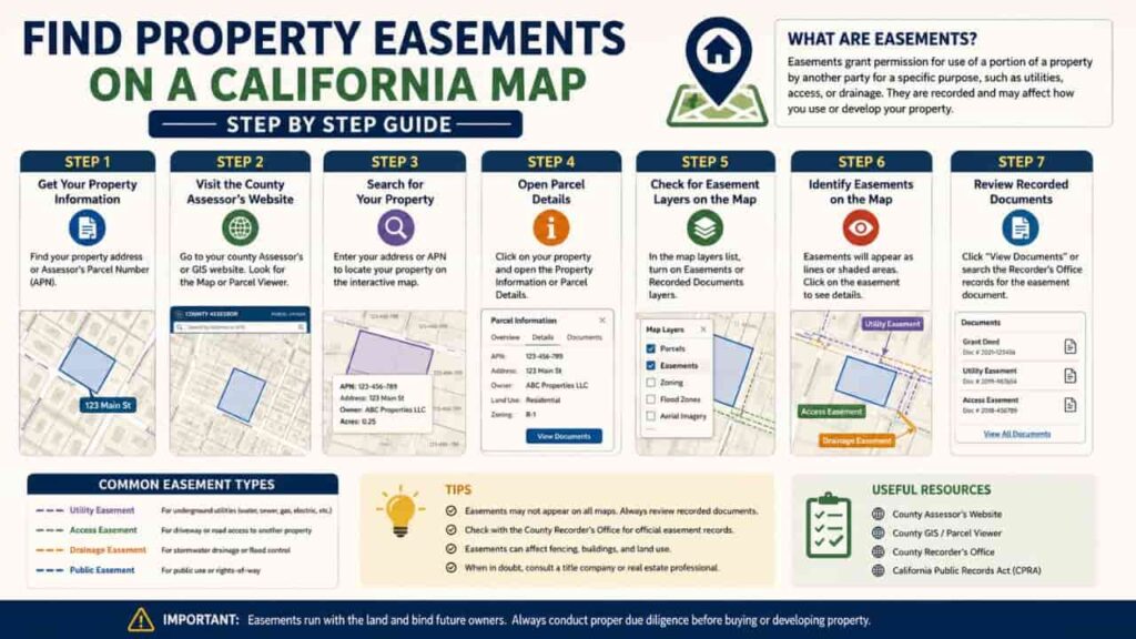
Step by Step Guide, How to Find Property Easements on a Map
If you want to audit a property for hidden access corridors or pipeline paths, follow this step by step professional workflow.
Step 1. Obtain Your Property’s Preliminary Title Report
When purchasing a home, your title insurance company will generate a preliminary title report. Open this document and look directly at the “Schedule B, Section II” exclusions. This section lists every single recorded easement text profile tied to your deed.
Step 2. Retrieve the Official Book and Page Numbers
The title report will reference a specific book and page number where the original easement contract or master subdivision map was recorded (e.g., Book 45, Page 12 of Maps). Note these numbers carefully.
Step 3. Pull the Master Plat Map via County Portals
Go to your local county recorder’s public access records portal. Input the book and page coordinates to pull up the high resolution, certified historical master plat map for your specific neighborhood block.
Step 4. Scan the Map for Dashed Lines and Text Abbreviations
Look closely at your specific lot borders. Easements are rarely drawn with solid borders. Instead, search for thin dashed lines or dotted margins running parallel to your property edge.
Step 5. Cross Verify with a Local Interactive GIS Portal
Open your city or county’s interactive GIS property lookup tool. Toggle on the “Infrastructure,” “Sewer Utilities,” and “Public Rights of Way” layers to visually verify if any active municipal utility mains cross your land layout.
How to Decode Map Symbols, Reading Easement Linework
Reading a professional engineering map requires knowing what the abbreviations and line styles mean. If you misinterpret a line, you could miscalculate your total buildable area.
Decoding the Text Abbreviations
Drafting technicians use shorthand to keep maps clean and readable. Look out for these standard California mapping codes.
- P.U.E. (Public Utility Easement)
This is the most common label. It indicates that power, water, gas, or telecom providers have an active right to install or service infrastructure on that strip of land. - I.E. / S.E. (Ingress & Egress / Slope Easement)
Ingress and Egress means a formal right of way for entry and exit. A slope easement means the local public works department has the right to manage soil grades to keep public roads from sliding onto your yard. - D.E. (Drainage Easement)
Reserved for storm drains, open concrete culverts, or natural creek flows. You cannot build walls or sheds over a D.E. because it can block rainwater runoff and cause flooding.
Analyzing the Linework
- Solid Outer Border. Represents your true, deeded property boundary line.
- Dashed Internal Lines (
----). Indicates the boundary of an internal easement corridor. The space between the solid line and the dashed line represents the area where your construction and land rights are restricted.
Key Takeaways
Learning to find property easements on a California map is a critical part of smart property management. Before finalizing architectural drawings or buying land, make sure to read your preliminary title report carefully and double check your plat map symbols. By finding these boundaries early, you can keep your projects compliant, avoid legal disputes with neighbors or utilities, and ensure your building plans sit safely on unrestricted land.
FAQs
Can a homeowner build a fence across a utility easement in California?
Yes, but with caution. Most utilities allow fences, but if they need to access underground pipes or wires, they have the legal right to tear down the fence without reimbursing you.
How do I remove an old easement from my California property?
You must secure a formal “Quitclaim Deed” from the easement holder, or prove in court that the easement has been abandoned for at least 20 consecutive years.
What is the difference between an easement and a setback?
An easement gives another party specific access rights to your land, while a setback is a local zoning rule that requires you to keep buildings a minimum distance from your property lines.
Do unrecorded easements still apply to new property buyers?
Yes. “Implied” or “prescriptive” easements can be legally binding if a neighbor or the public has used a path openly and continuously for over 5 years.
Will an official county assessor map show all utility lines?
No. Assessor maps are designed primarily for tax tracking. To find specific utility lines, you need to check the recorded plat map or contact 811 to trace underground pipes.
Where can I find my property’s preliminary title report?
Your title insurance company or escrow officer generates this report during the closing process when you buy a home or land parcel.
What does “Right of Way” mean on a property map?
A right of way is a specific type of easement that grants someone else the legal right to travel across a designated strip of your land to reach another area.
Can a utility company trim trees on my private property?
Yes. If tree branches grow into a designated utility easement or threaten overhead power lines, the company can trim them to keep the utility paths clear.
What does the abbreviation “P.U.E.” stand for on a plat map?
P.U.E. stands for Public Utility Easement, which reserves space along the property edge for gas, water, electric, or fiber optic lines.
Can I build an ADU over a recorded drainage easement?
No. Local planning departments will automatically reject building permits for structures like accessory units or sheds that block a recorded drainage path.