When digging into California public records to verify a property’s true footprint, you will likely come across two terms that sound almost identical, Plat Maps and Parcel Maps. To the untrained eye, both look like technical overhead sketches filled with lines, numbers, and geometric shapes. However, mistaking one for the other during real estate due diligence can lead to costly mistakes, especially if you are planning a structural development, managing a boundary dispute, or validating a legal property description before closing a real estate deal. While both are legally recognized mapping documents used across the Golden State, they serve entirely different administrative and structural purposes. This expert guide breaks down the core differences in the California plat map vs parcel map debate, explains how local county recorders index these maps, and shows you how to read them like a professional.
The Core Definitions, Plat Maps vs Parcel Maps
To understand how these documents work in California real estate, we have to look at their primary legal intentions.
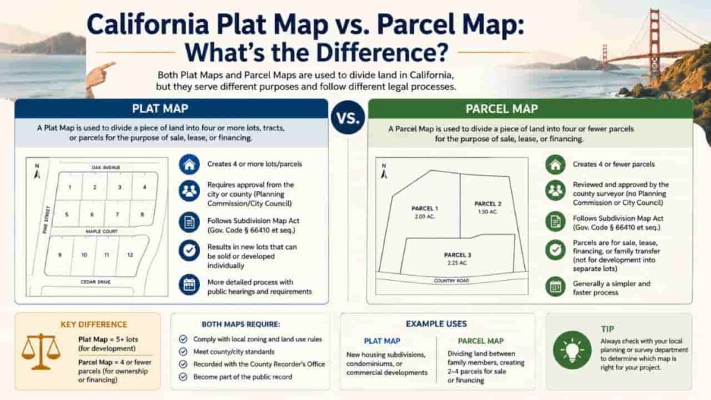
What is a California Plat Map?
A plat map (often derived from a subdivision plat) is a large scale, surveyed map that shows how a large tract of undivided land has been split into smaller individual lots, blocks, and streets. Plat maps are created by licensed land surveyors and must go through a formal approval process with a local city planning commission or county board of supervisors before being accepted into the public records. A plat map’s primary purpose is to establish the official geometric footprint of a newly planned neighborhood, ensuring that roads, public spaces, and utility configurations match local master plans.
What is a California Parcel Map?
A parcel map is a more focused, practical drawing primarily maintained by the local County Assessor’s Office. Its main purpose isn’t to layout a new neighborhood, but rather to identify individual pieces of land for property tax assessment. Parcel maps show current lot lines, dimensions, and unique identifier codes for parcels within a county. Because their main purpose is fiscal tracking, parcel maps change more frequently than plat maps. For instance, if a property owner legally splits a larger lot into two smaller ones, the county assessor updates the parcel map to reflect the change.
Key Differences, California Plat Map vs Parcel Map
While both documents deal with land boundaries, they differ significantly in their specific data layers, who creates them, and how they are used.
The table below outlines the core differences you need to know.
| Feature / Detail | California Plat Map | California Parcel Map |
| Primary Purpose | Legal creation and recording of a new subdivision or neighborhood development layout. | Fiscal tracking, property tax assessment, and internal government record keeping. |
| Created By | Licensed Professional Land Surveyors (PLS) using precise field measurements. | County Assessor’s drafting technicians using recorded deed descriptions. |
| Data Included | Street names, precise survey monuments, easement data, and dedicated public spaces. | Assessor’s Parcel Numbers (APNs), basic lot dimensions, and adjacent parcel boundaries. |
Understanding the “Book and Page” Indexing System
If you look closely at a certified California real estate deed, you will rarely see a generic description like “the blue house on Main Street.” Instead, you will find a highly structured legal description that reads similarly to this.
Lot 14 of Tract No. 4502, in the City of Los Angeles, County of Los Angeles, State of California, as per map recorded in Book 112, Pages 45 through 47 of Maps, in the office of the County Recorder of said County.
This is the official book and page number indexing system. It serves as the definitive way California’s 58 county recorders track legal property maps.
[County Recorder Database] ──> [Specific Book Number] ──> [Specific Page Number] ──> Verified Legal Map
How to Use Book and Page Numbers for Research
- The Book Number. Refers to the physical or digital volume where the certified master survey map was bound.
- The Page Number. Directs you to the exact sheet within that volume where your specific subdivision or tract layout is drawn.
When a title company runs a chain of title search to guarantee a clean transfer of ownership, their field agents look up these exact coordinates at the County Recorder’s Office. If a boundary dispute ever goes to court, a judge will rely on the map found at this indexed location to determine the true legal boundaries of the property.
Step by Step Guide, How to Find and Verify Your Property Maps
If you need to look up a property’s plat or parcel map for a real estate deal or build project, follow this professional step by step process.
Step 1. Locate Your Assessor’s Parcel Number (APN)
Find your unique 10 to 12 digit APN on a recent property tax statement or look it up by address on your county assessor’s website.
Step 2. Pull the Assessor’s Parcel Map Online
Visit your local county assessor’s interactive GIS portal or online parcel search tool. Input your APN to view and download the current tax parcel map showing your basic lot lines and dimensions.
Step 3. Locate the Legal Description on Your Grant Deed
Review your property’s grant deed to find the specific legal description. Look closely for the specific book and page number references pointing to the master subdivision plat.
Step 4. Retrieve the Official Plat Map from the County Recorder
Go to the official County Recorder’s Office website (or visit their public records counter). Use their map lookup tool to enter the book and page numbers you found on your deed to view the official surveyed plat map.
Reading Map Details, Identifying Overlays and Easements
When analyzing your downloaded maps, you must know how to identify hidden land restrictions that can impact your build plans.
Locating Easement Data
Plat maps are highly valuable because they show detailed easement data. An easement is a legal right that allows an outside party such as a utility company or a neighboring property owner to access or use a specific portion of your land. On a plat map, these are typically marked with light dashed lines along with labels like “O.H.E.” (Overhead Electrical Easement) or “P.U.E.” (Public Utility Easement).
Verifying Physical Accuracy
Remember that a parcel map is primarily a reference tool for property tax values and may not show every minor lot adjustment. If you plan to build a new structure near your property line, do not rely solely on a county parcel map. Instead, refer to the officially recorded plat map and consider hiring a licensed land surveyor to stake out your physical boundaries.
Key Takeaways to Protecting Your Real Estate Investments
Understanding the distinct differences between a California plat map vs parcel map is a foundational step for successful property research. While parcel maps provide a quick way to check your APN and tax boundaries, the recorded plat map remains the definitive legal document for neighborhood layouts and property descriptions. By learning to use the county recorder’s book and page number system, you can protect your real estate investments and ensure your project plans match your actual property rights.
FAQs
Is a California parcel map the same as a plat map?
No. A parcel map is an assessor’s diagram focused primarily on tax valuations, while a plat map is an officially surveyed layout of an entire subdivision.
Where can I find the book and page number for my property?
These index numbers are located within the written legal property description section on your home’s official grant deed or title insurance policy.
Can I use a county parcel map to resolve a boundary dispute?
No. Parcel maps are designed for tax tracking purposes only. To resolve a legal dispute, you must consult the recorded plat map or order a physical survey.
What does “subdivision plat” mean in California real estate?
A subdivision plat is an official surveyed map showing how a large parcel of land has been legally divided into individual residential lots and streets.
Are public plat maps free to view in California?
Many county assessor portals allow you to view basic parcel maps for free online, but county recorders often charge a small fee to download certified copies of official plat maps.
What is marked by dashed lines on a recorded plat map?
Dotted or dashed lines on a plat map typically indicate utility lines, drainage access paths, or shared driveway easement data.
Why does my property deed reference a tract map?
In California, a tract map is a type of plat map used to record large residential developments that create five or more new lots.
How often are county assessor parcel maps updated?
County drawing technicians update parcel maps throughout the year as lot splits, property line adjustments, and new deeds are officially recorded.
Who creates official plat maps in California?
Plat maps must be drawn and certified by a licensed Professional Land Surveyor (PLS) or a registered civil engineer authorized to practice land surveying.
What happens if a parcel map description conflicts with a plat map?
The officially recorded plat map referenced in your legal deed almost always takes precedence over an assessor’s parcel map in legal boundary matters.