Before you sign a contract to purchase a residential lot, commercial space, or empty land acreage in California, there is one critical question you must answer. What are you legally allowed to do with this land? Many buyers make the mistake of assuming that if a lot is empty, they can build whatever they want. Others assume a single family home can easily be turned into a commercial business. In the Golden State, these decisions are strictly governed by local municipalities. If you skip running a proper zoning lookup before closing escrow, you risk getting stuck with a piece of land that cannot be developed for your intended purpose. Fortunately, checking a property’s land use rights is completely free and accessible online. This expert guide will walk you through the official, step by step process to check property zoning in California, read county assessor maps, and secure an official zoning certificate from a local planning commission.
What is Land Use Classification in California?
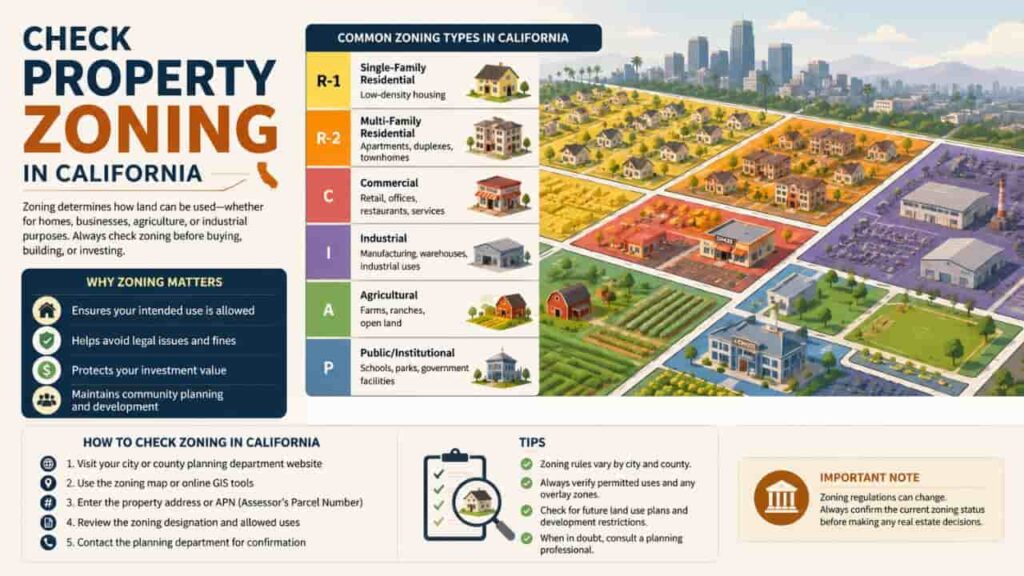
Every parcel of land in California is assigned a specific land use classification. These classifications are managed by local cities or, if the property is located outside city limits, by the county’s unincorporated planning department.
[State Planning Laws] ──> [City/County General Plan] ──> [Specific Parcel Zoning Code]
Zoning ordinances control the physical layout of communities by grouping land into distinct functional sectors. These sectors dictate density, building sizes, parking configurations, and even environmental safety parameters.
Where to Find Official California Zoning Information
When you run a parcel search, you must make sure you are pulling records from authentic government databases. Avoid relying blindly on third party real estate platforms like Zillow or Redfin for zoning data, as their pulled information is frequently outdated or missing critical local amendment changes.
The table below outlines the primary official government sources where you can securely verify zoning data across California.
| Government Agency | Type of Map / Portal Provided | Primary Administrative Purpose |
| City Planning Department | Incorporated GIS Viewers & Municipal Portals | Manages land use within official city borders (e.g., San Diego Municipal Code). |
| County Assessor’s Office | County assessor maps & Cadastral Registries | Tracks Assessor’s Parcel Numbers (APNs), lot boundary lines, and property tax values. |
| County Planning Commission | Unincorporated GIS & General Plan Portals | Governs all regional lands sitting outside formal city limits (rural or mountain areas). |
Step by Step Guide, How to Complete a California Zoning Lookup
Ready to audit your property? Follow this verified municipal workflow to find the exact zoning designation and development parameters for any property parcel.
Step 1. Retrieve the Assessor’s Parcel Number (APN)
Locate the target property’s unique APN. This 10 to 12 digit identification code is assigned by the county tax collector. You can easily find it printed on the most recent property tax bill, a grant deed, or by searching the street address on the local county assessor’s lookup tool.
Step 2. Access the Local Government GIS Mapping Portal
Determine if the property is inside an incorporated city or sits in an unincorporated county zone. Go to the official city or county planning website and launch their interactive GIS mapping portal (such as LA County’s Net GIS or Sacramento County’s Parcel Viewer).
Step 3. Locate the Parcel and Identify the Code
Input the APN or street address into the mapping portal’s search bar. Once the map highlights your exact lot boundaries, look at the active layers panel and record the alphanumeric code assigned to your parcel (e.g., R-1, C-3, or M-1).
Step 4. Cross Reference the Local Municipal Code Text
The code alone doesn’t tell the whole story. You must open the city or county’s online municipal code database (frequently hosted on public legal repositories like Municode or American Legal Publishing). Look up the exact section matching your code to review permitted uses, setbacks, and height caps.
Step 5. Request an Official Zoning Letter or Certificate
If you need legal proof of land use rights for a construction loan, commercial business license, or major development project, submit a formal request to the local planning department for a certified Zoning Verification Letter (ZVL).
Reading Between the Lines, Base Zones vs Overlay Districts
When you verify a property’s base zone classification, you are only seeing part of the legal picture. California heavily uses overlay districts, which add extra layers of rules right on top of the base zoning code.
Understanding Special Overlays
An overlay district can place stricter limits on a property or grant special developer bonuses, regardless of what the base code says. Common examples in California include.
- Historic Preservation Overlay Zones (HPOZ)
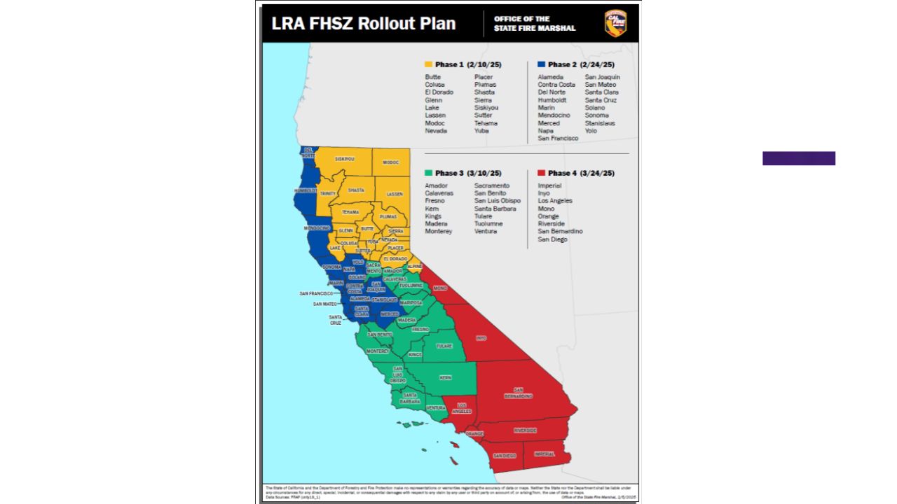
If a property falls within an HPOZ, you cannot modify exterior windows, paint colors, or building facades without formal approval from a local architectural review board. - Very High Fire Hazard Severity Zones (VHFHSZ)
These state mapped overlays require builders to use fire resistant materials, maintain defensible space clearings, and install indoor fire sprinklers. - Transit Oriented Development (TOD) Overlays
Parcels near major light rail or bus lines frequently receive density bonuses, allowing for taller buildings and lower mandatory parking minimums to promote public transit usage.
Key Takeaways
Taking the time to check property zoning in California is an essential piece of real estate due diligence. By using official county assessor maps, searching by the parcel’s APN, and cross referencing your codes with updated municipal ordinances, you protect yourself from expensive project delays and zoning violations. Before finalizing any land purchase or closing on a property deal, always verify your design concepts with local planning commission staff to ensure your investment is fully protected.
FAQs
Where can I find my property’s APN number in California?
You can find your Assessor’s Parcel Number (APN) on your annual property tax bill, your home’s grant deed, or by running an address search on your local county assessor’s web portal.
Can I change the zoning classification of a property in California?
Yes, but it requires filing a formal application for a Zoning Map Amendment with the local planning commission. The process is expensive, requires public hearings, and can take months to complete.
What is a Zoning Verification Letter (ZVL)?
A ZVL is an official document issued by a city or county planning department that legally certifies a parcel’s current zoning designation, permitted land uses, and code compliance status.
What happens if a building’s use doesn’t match local zoning laws?
If the building was constructed before the zoning law changed, it may be classified as a legal non conforming use (grandfathered in). Otherwise, it is an illegal code violation subject to heavy city fines.
How do I check if my property sits in an unincorporated area?
Run a parcel search on your county’s interactive GIS portal. If the administrative data field lists the jurisdiction as “Unincorporated,” your land use is governed by the county rather than a city.
Do California zoning laws regulate home businesses?
Yes. Most residential zoning codes allow for low impact home occupations, but they often restrict customer traffic, signage, inventory storage, and the hiring of outside employees.
What is a Conditional Use Permit (CUP)?
A CUP is a special administrative approval that allows a business to operate a use not typically permitted by right in that zone, provided they meet specific operating guidelines.
Are city zoning maps different from county assessor maps?
Yes. Assessor maps focus primarily on property tax valuations, acreage, and legal lot boundary dimensions, while city zoning maps focus entirely on land use rules and building limits.
Can local zoning codes block state approved ADU builds?
No. California state housing mandates directly override local ordinances, preventing cities from using local density rules to block compliant Accessory Dwelling Units.
Who should I talk to if I don’t understand a zoning code?
You should schedule a consultation or visit the public planning counter at your local city hall or county administration building to speak directly with an active duty planner.