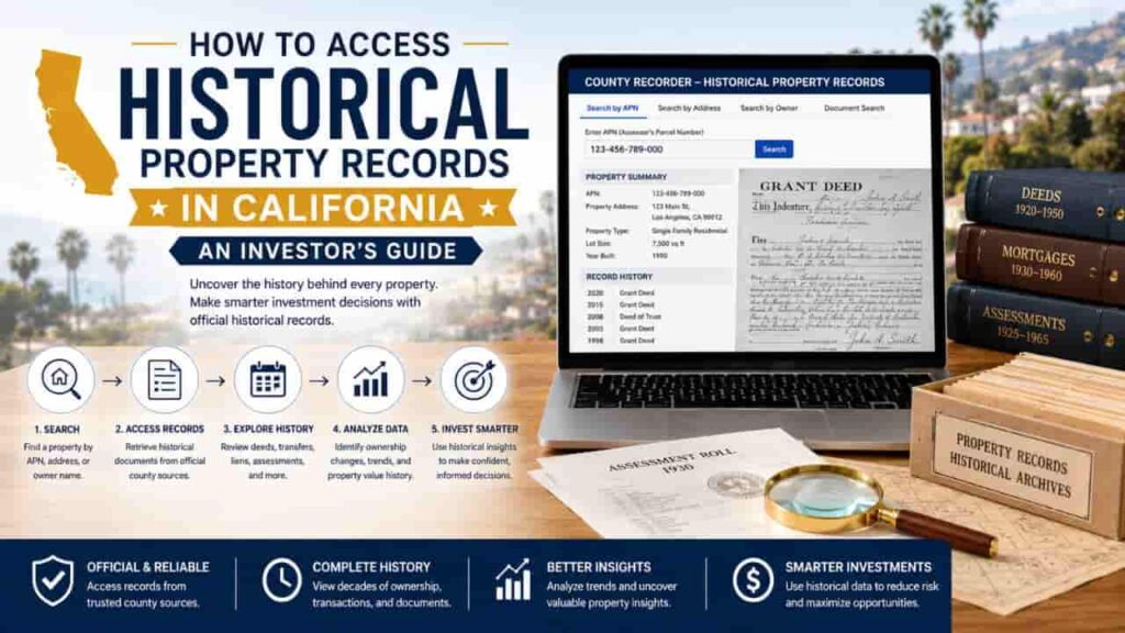
When evaluating real estate investments in the Golden State, looking at the current list price or the most recent tax assessment is only half the battle. To truly understand a property’s financial trajectory, risk profile, and future yield potential, smart real estate investors conduct deep historical research. Uncovering the historical property records in California allows you to establish an uninterrupted chain of title, identify hidden long-term encumbrances, and accurately calculate the historical compound annual growth rate (CAGR) to project future real estate appreciation. However, because California manages land documents via a highly decentralized, county-by-county administrative structure, tracing records back 30, 50, or even 100 years requires distinct methodologies compared to pulling standard modern records. This guide outlines the exact, official frameworks to successfully execute a comprehensive property history search using authentic government resources.
Why Historical Property Records Matter to Smart Investors
For sophisticated real estate acquisitions, historical records provide empirical, mathematical clarity rather than speculative marketing data. Investors primarily analyze historical property data to calculate real estate appreciation patterns and uncover title vulnerabilities.
Calculating True Real Estate Appreciation in CA
To understand how a property reacts to market cycles, inflation, and localized zoning modifications, you must analyze its purchase price history across multiple decades. By evaluating past sales figures against contemporary valuations, you can determine if a submarket consistently outperforms or underperforms the state average. This long-term dataset prevents you from overpaying during localized market peaks.
Establishing a Clean Chain of Title
A property history search uncovers every individual or entity that ever held a legal stake in the parcel. Tracing historical deeds ensures there are no active gaps in ownership, unresolved probate disputes, or ancient easements that could stall a future sale, refinance, or major structural redevelopment project.
Where California’s Historical Land Records Are Stored
Modern digital portals typically only archive transactional histories going back to the mid-1990s or early 2000s. To search deep historical data, you must understand where older, physical, and microfilmed public records are legally archived.
| Archival Repository | Type of Data Maintained | Best Used For |
| County Recorder’s Historical Index | Microfilm rolls, ancient plat maps, bound grantor/grantee leather ledgers. | Locating historical deeds, original homestead filings, and ancient mortgages. |
| County Assessor’s Archives | Historical tax assessment rolls, building permit history, and parent parcel records. | Determining original build dates, structural modifications, and historical tax bases. |
| California State Archives / Local Historical Societies | Land patents, Spanish-Mexican land grant titles, and historical aerial photography. | Investigating foundational pre-statehood boundaries or historical preservation status. |
Step by Step Blueprint to Conduct a Property History Search
Follow this official sequence to uncover past owners, trace title instruments, and map out a parcel’s complete financial and structural history.
Step 1: Trace the Parent Parcel and APN History
Before searching for historical deeds, you must establish the property’s current Assessor’s Parcel Number (APN). However, if you are researching a property in an older, historic subdivision, keep in mind that APNs change over time when large tracts of land are subdivided into smaller individual lots.
- Visit the local County Assessor’s office and request to view the property’s historical tax maps or “master parcel ledger.”
- Trace the current APN backward to identify its original “parent parcel” number. This ensures that you do not miss critical title recordings filed under an outdated parcel numbering format.
Step 2: Utilize the Historical Grantor/Grantee Indexes
To trace past owners, you must use the county recorder’s historical index system. Because older documents are not searchable by street address, you must work backward chronologically using legal names.
- Identify the current owner (the Grantee) on the most recent deed.
- Search the index backward under that name to find the deed where they originally acquired the property. On that older deed, locate the seller’s name (the Grantor).
- Take that seller’s name and run it through the historical index as a Grantee to discover who sold the property to them.
- Repeat this structural, leapfrog process to systematically build an unbroken chain of title across decades.
Step 3: Access Microfilm and Physical Ledger Books
For transactions executed prior to the digital transition of the late 20th century, you will need to request access to physical media.
- Visit the main archival branch of the County Clerk-Recorder.
- Cross-reference the book and page number found in the historical index with the county’s physical microfilm library or bound historical record volumes.
- Review the actual scanned image of the handwritten or typed historical deed to confirm transaction values, witness signatures, and specific boundary descriptions.
Step 4: Extract Historical Sales Data to Calculate Appreciation
Once you have successfully compiled a chronological list of historical sales prices and transfer dates, you can apply standard financial metrics to evaluate the investment value.
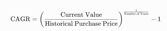
Using this formula allows you to compare the historical compounding growth of a specific piece of real estate directly against alternative asset classes like the S&P 500 index.
Technical Obstacles in California Historical Research
When examining ancient property data in California, researchers frequently encounter specific technical anomalies that require specialized handling:
- Documentary Transfer Tax Math:
Older deeds often do not explicitly state the final purchase price due to historical privacy preferences. Instead, look for the Documentary Transfer Tax stamp affixed to the face of the document. You can reverse-engineer the exact purchase price by dividing the stated tax amount by the historical statutory tax rate ($1.10 per $1,000 of consideration value). - Spanish Mexican Land Grants:
In historic regions of Southern California and the Central Valley, title chains can end abruptly in the mid 1800s. These parcels originate from massive historic ranchos granted prior to California’s statehood in 1850. To trace these further, you must query the Spanish Land Grant Records archived specifically by the California State Lands Commission. - Unrecorded Wild Deeds:
Occasionally, a historic transfer was executed privately but never formally recorded with the county. A “wild deed” breaks the public chain of title. To resolve this issue, you must cross-reference probate court administration files or order an abstract from a private title plant that utilizes internal tracking indices.
Step by Step Investor Due Diligence Framework
To seamlessly integrate historical research into your standard property acquisition workflow, utilize this operational checklist during your initial escrow evaluation phase:
1.Secure Current Base Data: Phase 1.
Pull the modern property profile from the County Assessor to verify the current APN, tract name, and legal lot description.
2.Map the Deed Timeline: Phase 2.
Access the County Recorder’s public terminals to build an unbroken chain of title going back at least 40 to 50 years.
3.Audit Historical Encumbrances: Phase 3.
Review the historical index files for unreleased mechanics liens, ancient mortgages, long-standing utility easements, or restrictive covenants.
4.Perform Financial Appreciation Analysis: Phase 4.
Extract all historical purchase points, adjust for inflation, and compute the true structural appreciation rate to validate your underwriting projections
Conclusion
Conducting a historical property records search in California provides investors with the unvarnished data required to calculate real estate appreciation trends and minimize portfolio risk. By moving past modern web portal limitations to audit physical microfilm archives, old plat maps, and the official Grantor/Grantee index, you can establish an ironclad chain of title. Unlocking these historical deeds ensures your underwriting is backed by authentic data, protecting your capital from market anomalies and hidden encumbrances across California’s 58 counties.
FAQs
How far back do digital historical property records go in California?
Most online county portals only archive digital land title histories back to the mid-1990s or early 2000s. Older historical records require inspecting physical microfiche, film rolls, or bound ledgers.
How can I find the original purchase price on an old California deed?
If the sale price is hidden, look for the Documentary Transfer Tax stamp on the deed. Reverse-engineer the price by dividing the tax amount by the statutory rate ($1.10 per $1,000).
What is a “wild deed” in a California chain of title?
A wild deed is an executed property transfer that was never properly indexed in the county recorder’s public files. It creates an unrecorded break in the historical chain of title.
Can I search historical property records in California by street address?
No. Historical land archives are organized chronologically. You must use the Grantor/Grantee index to search alphabetically by individual or corporate name to trace past ownership deeds sequentially.
Where are pre-1850 Spanish Mexican land grant records located?
Foundational property records predating California’s statehood are not kept at standard county offices. These unique historical files are preserved within the California State Archives located in Sacramento.
Do historical property records show old building permit files?
Yes. The County Assessor’s archives maintain historical property characteristics and building card records, which document original construction dates, structural footprints, and major past renovations.
Why did the historical APN change on my investment property?
Assessor’s Parcel Numbers (APNs) change when historic parent parcels are subdivided into smaller lots, or when municipal tax map boundaries are updated by the county GIS department.
Professional Disclaimer: This guide is intended exclusively for educational and strategic investment mapping purposes. It does not constitute formal legal counsel, certified title underwriting, or professional financial advising. Historical public records can contain transcription errors or omissions. For formal transactional guarantees, always secure a comprehensive preliminary title report from a licensed title insurance company.