
Is your dream California home sitting directly on an active earthquake fault line, or nestled deep within a volatile wildfire danger zone? When purchasing real estate in the Golden State, failing to audit a property’s historical vulnerability to natural disasters can be a devastating financial mistake. A home with an undisclosed history of damage might look flawless during a staging walk through, but underlying geological or environmental risks could make it completely uninsurable. To safeguard your investment, you must move past marketing brochures and dive deep into official state and federal public databases. Understanding how to pull a California property natural hazard history report ensures you uncover hidden past disasters before signing a binding contract.
1. Tracking Seismic Vulnerabilities, Using the Fault Lines Map
California is famous for its dynamic geology, making seismic safety a fundamental part of local real estate due diligence. Buying a property built directly over a fault line significantly increases the risk of structural collapse during a major earthquake.
The Alquist Priolo Earthquake Fault Zoning Act
Passed in 1972, this crucial piece of legislation prevents builders from placing structures intended for human occupancy directly over the traces of active faults. If a property lies within a designated Alquist Priolo Zone (usually a quarter mile wide strip along an active fault line), it carries strict construction and disclosure mandates.
Where to Verify Seismic Data
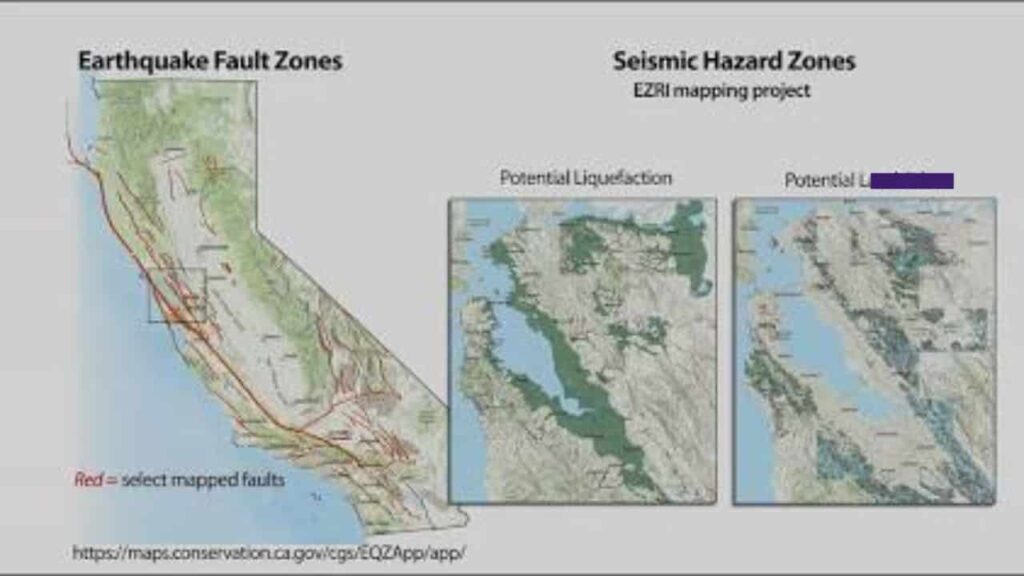
- California Geological Survey (CGS)
Use the interactive EQZApp (Earthquake Zones of Required Investigation) tool. By entering a specific parcel address, you can view the official state fault lines map. - Liquefaction and Landslide Maps
The same CGS portal highlights areas prone to liquefaction (where solid ground behaves like quicksand during shaking) and seismically triggered landslides.
2. Wildfire Risk Assessment, Evaluating State Fire Hazard Zones
Uncontrolled wildfires represent one of the most prominent threats to California real estate. A property’s proximity to dense brush or fire prone canyons directly impacts your safety, building requirements, and property insurance eligibility.
Understanding State Fire Portals
To evaluate localized fire history and future vulnerabilities, homeowners must consult the California Department of Forestry and Fire Protection (CAL FIRE).
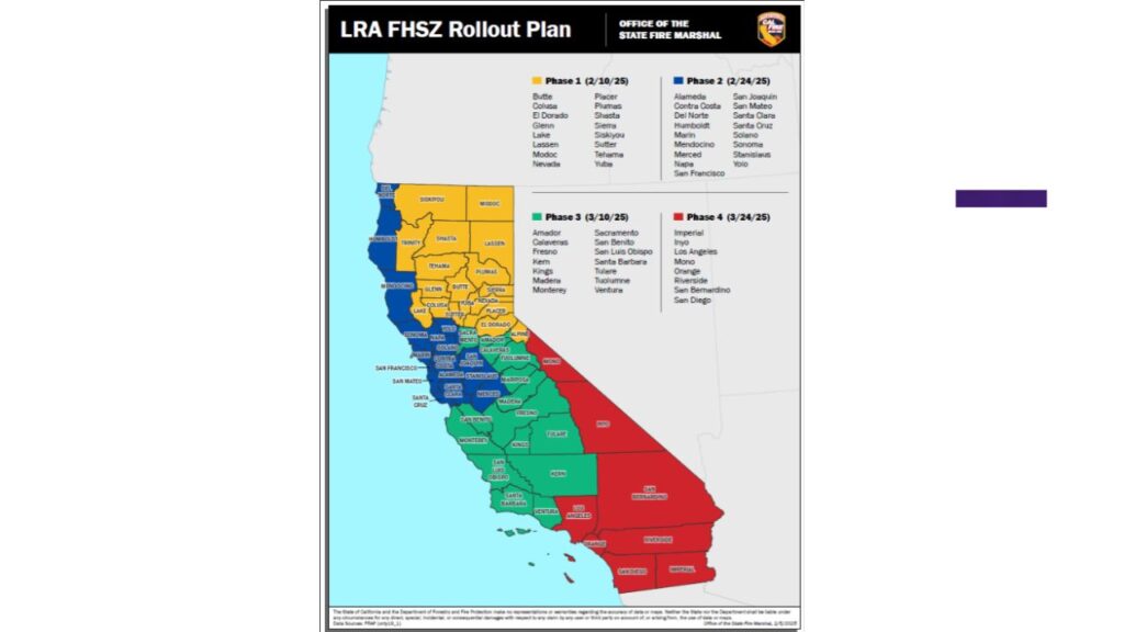
- Fire Hazard Severity Zones (FHSZ)
CAL FIRE maps specify whether a property sits within a Moderate, High, or Very High FHSZ. Properties located in a “Very High” zone under State Responsibility Areas (SRA) face strict building codes. - Defensible Space Regulations
Properties in high risk zones must comply with California Public Resources Code 4291, requiring a 100 foot clearing of vegetation around all structures.
Warning. If a home is located within a Very High Fire Hazard Severity Zone, standard private insurers may deny coverage. Your only option might be the state backed California FAIR Plan, which offers basic fire insurance at significantly higher premium rates.
3. Historic Flood Zones, Identifying Hidden Water Damage
Surface appearances are notoriously deceptive when it comes to historical water damage. A home located miles away from a visible river or coastline can still sit inside vulnerable historic flood zones due to localized drainage failures or seasonal atmospheric rivers.
To trace historical flooding anomalies and current flood designations, tap into federal hydrological resources.
- FEMA Flood Map Service Center
- Enter your specific address to pull the current Flood Insurance Rate Map (FIRM). Look closely for Special Flood Hazard Areas (SFHAs) labeled as Zone A or Zone AE.
- National Flood Insurance Program (NFIP)
Review local community status books to see if the municipality participates in federal flood mitigation frameworks.
If the property sits inside a Special Flood Hazard Area, federal law mandates purchasing secondary flood insurance if you secure a federally backed mortgage.
4. The Environmental Hazard Disclosure Statement
In California, state law builds a protective buffer for buyers through mandatory seller disclosures. Understanding how to read these reports is essential for evaluating a home’s structural integrity.
The Natural Hazard Disclosure (NHD) Report
Under California Civil Code Section 1103, sellers must provide a comprehensive environmental hazard disclosure report before closing escrow. This report is compiled by third party statutory compliance firms using official government geographic data.
Statutory Zones Tracked in an NHD Report
- Special Flood Hazard Areas (FEMA Zone A/V).
- Dam Inundation Zones (areas at risk if a local reservoir dam fails).
- Very High Fire Hazard Severity Zones.
- Wildland Fire Areas subject to forest fire exposure.
- Alquist Priolo Earthquake Fault Zones.
- Seismic Hazard Zones (Liquefaction and Landslides).
California Natural Hazard Verification Directory
To make your real estate due diligence process organized and highly efficient, use this comprehensive tracking directory built entirely around official public data clearinghouses.
| Hazard Type | Key Indicator to Verify | Official Government Agency Source |
| Earthquake Risk | Fault Lines, Liquefaction Zones | California Geological Survey (maps.conservation.ca.gov) |
| Wildfire Exposure | Fire Hazard Severity Classification | CAL FIRE Mapping Portal (fire.ca.gov) |
| Flooding Vulnerability | Historic Overflow, SFHA Designations | FEMA Flood Map Service Center (msc.fema.gov) |
| Structural Claims | Past Property Insurance Losses | Comprehensive Loss Underwriting Exchange (CLUE) |
| Local Environment | Landslide History, Dam Inundation | California Department of Water Resources |
5. Comprehensive Loss Underwriting Exchange (CLUE) Reports
While state maps tell you what could happen based on geography, insurance data tells you exactly what has already happened inside the walls of that specific home.
Before finalizing your mortgage, ask the seller to pull a CLUE Report from LexisNexis. This comprehensive insurance database tracks a rolling seven year window of all homeowner insurance claims filed on the property.
- Look for Hidden Damage
A CLUE report reveals past claims for water damage from broken pipes, minor electrical fires, or structural stabilization after minor earth movements. - Check Insurance Eligibility
If the property has multiple recent weather related or fire claims, underwriting algorithms may flag the home as uninsurable, completely blocking your loan approval.
6. Step by Step Natural Hazard Checklist for Homebuyers
Do not submit a non contingent offer on a California home without systematically completing this step by step public data validation workflow.
- Step 1. Run the parcel’s coordinates through the California Geological Survey EQZApp to verify it sits clear of active fault traces.
- Step 2. Check the address on the CAL FIRE FHSZ viewer to determine if the property faces severe wildfire risk restrictions.
- Step 3. Confirm the home’s flood zone safety status using the FEMA Flood Map Portal.
- Step 4. Review the statutory Natural Hazard Disclosure (NHD) Report provided by the seller, matching its boundaries against state data.
- Step 5. Contingently request a copy of the property’s CLUE Report to audit the past seven years of real world insurance claim payouts.
- Step 6. Contact a local insurance broker immediately during your inspection contingency window to confirm the home’s property insurance eligibility without exorbitant premiums.
Final Advisory
Securing a safe piece of California real estate requires a meticulous look at public data. By cross referencing active fault lines maps, studying a location’s wildfire risk area boundaries, and examining an official environmental hazard disclosure, you protect your family from volatile natural disasters. Always trust verified government data portals over real estate sales pitches.
FAQs
What is an Alquist Priolo zone in California real estate?
It is an official state designated zone surrounding active earthquake fault lines, managed under California law to prevent building habitable structures directly on top of faults.
How do I find out if a home has flooded previously?
Request a rolling seven year CLUE report from the seller to review past insurance claims, and check the address on the official FEMA Flood Map Service Center.
Can I get standard home insurance in a Very High Fire Zone?
Standard private home insurance carriers frequently deny coverage in these regions, requiring buyers to seek alternative coverage through the high premium California FAIR Plan.
Where can I find official California earthquake fault lines maps?
The California Geological Survey (CGS) provides a free, interactive mapping application called EQZApp that highlights every regulated seismic zone across the state.
What does soil liquefaction mean during an earthquake?
Liquefaction occurs when water saturated, loose soil temporarily loses its strength and acts like a fluid during intense seismic shaking, risking severe foundation damage.
Who pays for the Natural Hazard Disclosure report in CA?
By local custom and standard California real estate contract terms, the seller typically pays for and provides the comprehensive third party NHD report to the buyer.
How close to a fault line is safe in California?
Structures for human occupancy must generally be set back at least 50 feet from an active fault trace identified within an Alquist Priolo zone.
Does a standard home insurance policy cover earthquake damage?
No, standard homeowners policies explicitly exclude earth movement. You must buy separate coverage through the California Earthquake Authority (CEA) or private insurers.
How do I check for local dam inundation risks?
Review the property’s official environmental hazard disclosure (NHD) statement, which utilizes California Department of Water Resources maps to identify potential flood pathways from dam failures.
What are CAL FIRE State Responsibility Areas (SRA)?
SRAs are geographic locations where the state of California has the primary financial responsibility for preventing and suppressing intense wildland fires.


